Los Farallônes Project |
|
Property Description
- Los Farallônes (Spanish for "The Cliffs") is a 76 acre
property in the US Four Corners region in an unincorporated area of San
Juan County, NM. It is located in the Hartly Springs Ranchos subdivision
on the east side of County Road 1350 approximately 3.5 miles north of it's
junction with the La Plata/Aztec Road (Hwy. 574). This location is
just 2.5 miles south of the Colorado border. The planned building site as
at an elevation of 6,300 ft. (For comparison, Durango, CO, twenty miles
NNE, is at 6,500 ft.)
The bulk of the property is on a raised 'peninsula', jutting out a mile to the west-northwest from the main ridgeline, with Hartly Spring Canyon on the north and Max Canyon on the south. This peninsula terminates a hundred yards from C.R. 1350 in head cliffs with 40 foot scarps. The large ridgeline to the east, which runs for many miles, forms the west rim of Farmington Glade. Drainage from the west side of the main ridge and associated canyons is to Jaquez Arroyo, three miles west, and thence to the La Plata River. Los Farallônes enjoys 360 degree views including Shiprock (40 miles southwest) and the Chuska Mountains (AZ) beyond. Due west the view is to a parallel ridge forming the west bank of the La Plata River, approximately 15 miles distant on the west side of the La Plata Highway (Hwy. 170). The Mountain Ute Tribal Park is located beyond these hills. To the northwest Mesa Verde and Sleeping Ute Mountain form the horizon. To the north, into Colorado, are unobstructed views of the La Plata Mountains with the Mount Hesperus massif (30 miles distant) at 13,225 feet. Further distant to the northeast the San Juan Mountains create a snaggle-tooth horizon. Approximately a mile east and several hundred feet higher are the high cliffs at the head of Hartly Spring Canyon with monument quality weather sculpted sandstone. Completing the vista, southern views are of the ridgeline running into the distance and Hood Mesa, on the north side Farmington, NM, (20 miles south). The southern leg of the property spans the mouth of Max Canyon , a large box canyon on Bureau of Land Management (BLM) land to the east whose only vehicle access is through Los Farallônes. The northern rim of Max Canyon also contains many areas of well sculpted sandstone with hoodoos. Max Canyon wash traverses the extreme southern portion of the property as does a gas well service road. Another service road running east crosses the property along the north side of Max Canyon. The central section of the property (the 'peninsula' described above) incorporates extensive sandstone cliffs and Robin Canyon, a small box canyon with a large arch at the head and a seasonal waterfall. The northern portion of the property opens to Hartly Spring Canyon and includes a large wash draining the south side of that canyon. Los Farallônes, shaped like an inverted 'L' with a wide horizontal stroke, wraps around the northwest corner of a BLM section. The adjacent property to the north and east is held as common land for Hartly Springs Ranchos (the development) residents. A service road provides access to Hartly Spring Canyon and to the northeast corner of Los Farallônes. See aerial photo below. A driveway winding up and around the cliffs provides access to the building site via gate from C.R. 1350. The nearest town is Aztec, NM, approximately 10 miles SSE on Hwy 574 (Light Plant Road in Aztec city limits). Electric and water utilities extend to the property line along C.R. 1350. |
|
Project Goals - Los Farallônes land was purchased in 2001 with the intent of providing my final resting place (in this life). I hope to design and construct a residence and art/design studio and workshop in harmony with the incredible beauty and spirituality of the location. As of 2006 the only development has been to rough-in a road to the vicinity of the planned clifftop building site and construct a fence with three gates along C.R. 1350. Upon completion and sale of the Casa Vista project my current plan is to purchase a house in Aztec, NM (closer to Los Farallones) and work on the total project design for several years prior to commencing construction. Preliminary design concepts include a main structure with an upper level at grade on the high center of the 'peninsula' and a lower level cut-in and open to the south facing slope. A large paved plaza on the north side of the upper level and a patio on the south side of the lower level provide outdoor areas for relaxation or entertainment. Enclosed passageways from the lower level of the main structure, dropping an additional ten feet in elevation, would connect with a master suite built into a natural declivity in the cliff edge overlooking Robin Canyon to the south of the main structure. A continuation of the passageway approximately 100 feet further west along the canyon edge would lead to a Cliff Room (den) built into another preexisting natural declivity. A studio/workshop would be built as a freestanding structure approximately 100 feet northeast of the main structure at a lower level on the north slope of the 'peninsula' |
|
Los Farallônes Images - Picture - Caption
- Comment
Click on Thumbnails below to open a larger image in a new window. |
|
|
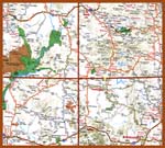
US Four Corners area road map. | Yellow dot between Farmington and Durango on NM/CO border indicates position of Los Farallônes. |
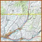 |
Regional topo map with 250 ft. contour. | Red dot indicates location of Los Farallônes, west of Farmington Glade and just below Colorado border line. |
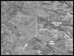 |
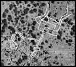
USGS Aerial Photo of Los Farallônes and vicinity. | Boundaries shown in white. Red dot is apx. Position of building site. 76 acres. |
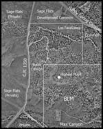 |
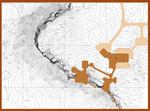
Commissioned aerial photo of Los Farallônes. Aerial photography and contour map provided by Thomas R. Mann & Associates, Inc. | Overlay with descriptive text; driveway, boundary line, , building sites and highest point in photo area. Master file resolution is 3 inches per pixel. |
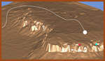 |
Bird's eye view to NE of of 3D model (in VRML file format) of west end of L.F. Peninsula. | White line follows driveway path from C.R. at left to clifftop site. Dots are main and cliff edge sites. |
 |
Aerial photo with rough sketch overlay of site concept. | Note rooms on north rim of Robin Canyon. |
 |
Topo with site concept overlay. One foot contour. | Covers slightly more area than aerial photo above. |
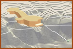 |
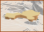
Bird's eye view from across Robin Canyon of cliff room 3D concept sketch model. | 3D model of site topology created from 2D contour data. Note stair, for access to floor of Robin Canyon. |
 |
Bird's eye view of 3D sketch model from west along cliff line. | Passageway connecting to main structure not shown. Structure nests into natural declivity in cliff edge. |
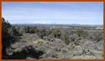 |
View north from site of main structure. | Mouth of Hartly Spring Canyon in foreground. La Plata Mts. on horizon. |
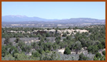 |
View NNW across Hartly Spring Canyon from south rim cliffs. | Taken in early summer from Hartly Spring Canyon south rim. |
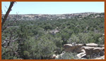 |
View east into head of Hartly Spring Canyon. |
Taken from location similar to above. |
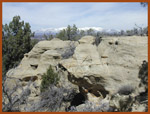 |
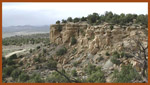
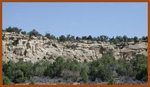
Section of lower cliffs on south rim of Hartly Spring Canyon. | These cliffs on the north side of the Los Farallônes peninsula. run for 1/4 mile. Very weather sculpted. |
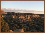 |
View from head cliffs south across mouth of Robin Canyon at sunset. | South head cliffs also part of Los Farallônes. BLM land to east (left side of view). |
 |
View ESE at sunset into Robin Canyon from north rim. | Seasonal waterfall over top of arch (snowmelt or cloud burst). |
 |
View west from north rim of Robin Canyon. | Cliff edge building sites along rim on right. |
 |
View of north rim of Robin Canyon from south rim. | C.R. 1350 visible at left. Canyon bottom thick with cedar and Piñon Pine. |
 |
View north of head cliffs and Robin Canyon north rim from C.R. 1350. | Forms the northwest end of a peninsula. between Hartly Spring and Robin Canyons. |
 |
View of north rim of Robin Canyon from south head cliff. | Red boxes indicate room sites in natural declivities. |
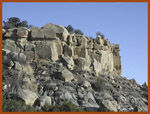 |
Main head cliff scarps. | View from C.R. 1350. |
 |
View from mouth of Robin Canyon of north rim. | Look for declivities in top edge where Cliff Room and Master Bd. Rm. will be. |
 |
View of Master Bd. Rm. declivity from above. | South head cliffs seen across mouth of Robin Canyon. C.R. 1350 in flats below. |
 |
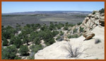
View north from head cliffs. La Plata Mountains in distance. | Clifftop in foreground. |
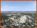 |
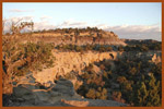
View west from high cliffs out over Los Farallones peninsula. | Head cliffs out at far end of peninsula in center of photo. Max Canyon at left, Hartly Spr. Canyon at right. |
 |
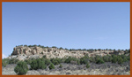
High cliffs at head of Hartly Spring Canyon. | La Plata Mountains in distance. |
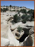 |
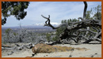
Hartly Spring. |
Spring down in dark hole at lower right. Feeds watering trough at head of canyon, drought permitting. |
 |
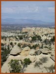
Doll's House area at head of Hartly Spring Canyon; BLM managed land. | Mesa Verde and Sleeping Ute Mountain on horizon at left; La Plata's on right. |
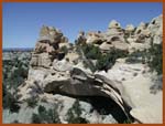 |
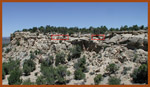
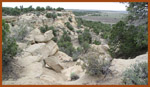
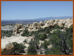
Doll's House close-up. | Acres of sculpted sandstone along rim of high cliffs. |
| Contact
Synoptic Designs |